
Overview
Stretching 600 miles (960 km) east to west with geographical features that range from mountains and valleys to high plains and badlands, Montana has several climates. West of the Continental Divide, its mountains lie within the furthest eastern reach of the moist Pacific maritime climatic zone. This area experiences more cloudy days and higher rainfall than the more arid areas to the east.
East of the Continental Divide, the mountains receive less rainfall than their western faces and are colder in winter. Their highest reaches are in a montane climatic zone, but their valleys and lowlands are in a semiarid continental climate that is marked by short, warm summers and cold, lingering winters with heavy snowfalls on the plains. This climatic zone extends across the state to the Dakotas.
However, the extremely mountainous nature and complex topography of Montana’s western third creates many microclimates, where wet highlands may be juxtaposed with dry lowlands, and precipitation figures, as well as temperatures, can differ dramatically over short distances.
Generally speaking, Montana is a cool state, one in which snowfall can occur in any month of the year, although it is rare in July and August. Although most places in the state can reach 90°F (32°C) or higher a few times each summer, the average daytime temperature range statewide in July is a temperate 64 to 88°F (17 to 31°C). In January, the coldest month of the year, the average daytime high statewide is 28°F (-2°C). In either case, warm or cold, the state’s low humidity is a major factor in keeping its weather from becoming uncomfortable.
Seasons
Winters are cold, with below-freezing temperatures. While the average daytime high temperature averages 28°F (-2°C), the daytime low plummets to 8.1°F (-13.3°C). Snows can begin as early as September, but generally begin falling in significant amounts in November. Snow accumulation in the mountains can reach 300 inches (7,620 mm/25 feet) or more. Winter-like temperatures can extend well into April, and there can even be heavy snowstorms in May, only weeks before the official start of summer. Chinook winds can warm areas to the east of the mountains to as high as 50 to 60°F (10 to 15.6°C).
Springs are cool, with daytime highs building from around 40°F (4.44°C) in March to 60°F (15.6°C) by May. Average lows, though, are 20°F (-6.67°C) in March, climbing to around 32°F (0°C) by May. Rainfall begins to pick up from its winter low but does not match summer precipitation. March marks the end of most snow seasons, although storms can arrive as late as May.
In summer, July and August are the warmest months, with daytime highs ranging from 64 to 88°F (17 to 31°C). At night, temperatures in the cooler western parts of the state drop down 50 to 60°F (10 to 15.6°C). Although temperatures in some parts of Montana can reach well past 90°F (32.2°C), hot weather above 4,000 feet (1,220 meters) is unknown.
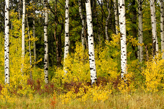
Autumn marks the beginning of the snow season, which sometimes starts as early as September, but more often in November. Bright fall foliage is common among aspen groves in the mountains and in cottonwoods along riparian streams.
Temperature
In terms of the difference between its all-time high and low temperatures, Montana ranks first among the states at 187°F (86.1°C). That's 7°F (3.9°C) more than Alaska, which holds the all-time U.S. record for the lowest temperature, -80°F (-62.2°C). Montana's all-time high temperature, 117°F (46.1°C), was reached twice in recorded history. It occurred first on July 20, 1893, at Glendive, in the state’s far east, about 30 miles (48 km) west of the North Dakota border. The second occasion was on July 5, 1937, at Medicine Lake, in the far northeast, about 18 miles (29 km) west of the border with North Dakota. The all-time coldest temperature, -70°F (-56.7°C), was set on January 20, 1954, at Rogers Pass, about 30 miles (48 km) northwest of Helena, in the state’s mountainous west.
Precipitation
With an annual statewide average rainfall of 15.37 inches (390 mm), Montana is the 45th wettest state in the U.S. However, rainfall varies widely according to elevation and location. The driest location in the state, Belfry, in Montana’s arid south-central high plains region just north of the Wyoming border, receives 6.85 inches (174 mm) of rain per year, a desert-like quantity. The wettest location, Glacier National Park’s Grinnell Glacier in the state’s northwest, receives 105 inches (2,667 mm) per year, thanks to its location in the wet maritime climatic zone that extends 400 miles (640 km) inland from Washington State to the western flank of Montana’s Rocky Mountains.
The one-year record for rainfall, 55.51 inches (1,410 mm), was set in 1953 at Summit, 50 miles (80 km) northwest of Yellowstone National Park. That is roughly the same amount the entire state of Alabama receives in a year (56.9 inches/1,445 mm).
Rainfall averages in the state’s major cities are very much like the totals in California cities. Helena, at 11.32 inches (288 mm) receives virtually the same amount of rain as Fresno (11.23 inches/285 mm) annually. Great Falls’ 14.89 inches (378 mm) is almost the same amount as the 15.14 inches (385 mm) Los Angeles receives per year. The wettest Montana city is Kalispell, which receives 17.21 inches (437 mm) of rain annually, a little less than Sacramento (17.63 inches/448 mm).
Snow is heavy in many places. The snowiest location is King’s Hill, 30 miles (48 km) southeast of Great Falls, which averages 305.5 inches (7,760 mm/25.5 feet) of snow per year. The state’s biggest cities average at least 45 inches (1,143 mm) of snow annually, ranging from 45.4 inches (1,153 mm) at Missoula to 64 inches (1,626 mm/ 5.33 feet) at Kalispell.
The all-time one-year snowfall record is 418.1 inches (10,620 mm/34.8 feet), set in 1977–78 at Cooke City in the extreme south, about two miles (3.2 km) east of the northeast gate to Yellowstone National Park.
Humidity
Overall, Montana has very low humidity, a condition that makes both its hot and cold weather more comfortable. Great Falls and Helena, which are well east of the Continental Divide, are very dry, with average relative humidity readings very close to those of Salt Lake City, Utah, a desert city. Kalispell and Missoula, located closer to the moist Pacific air masses that come from the west, have a higher average humidity that is comparable to Charlotte, North Carolina, 1,900 miles (3,040 km) to the east.
| Average a.m. Humidity | Average p.m. Humidity | |
| Great Falls | 68% | 46% |
| Helena | 72% | 45% |
| Kalispell | 82% | 54% |
| Missoula | 82% | 52% |
Sunshine
Despite Montana’s aridity, its biggest cities, clumped at the wetter western end of the state, do not enjoy as much sunshine as other western cities located in dry climates. Great Falls receives 61 percent of all available sunlight per year, a figure matched by the Dallas-Fort Worth area and Jackson, Mississippi. Billings receives 60 percent of all available sunlight, equal to Atlanta and Omaha. Helena, at 59 percent, receives the same percentage of sunlight as Houston, and Missoula’s 55 percent figure matches that of Indianapolis.
| Clear Days | Partly Cloudy Days | Cloudy Days | |
| Great Falls | 79 | 106 | 180 |
| Helena | 82 | 104 | 179 |
| Kalispell | 70 | 81 | 214 |
| Missoula | 75 | 83 | 208 |
Regions
Generally speaking, Montana has three distinct climatic regions: the western side of the Continental Divide, where the moist Pacific maritime climate reaches its furthest extent; the drier montane climate of the mountains east of the Continental Divide; and the semiarid continental steppe climate of the state’s mountain valleys and relatively flat eastern two-thirds.
Weather Extremes
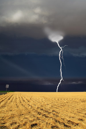
Montana ranks 43rd in the number of Major Disaster Declarations FEMA (Federal Emergency Management Agency) has issued for the 59 U.S. states, territories, and possessions. Since 1953, the state’s 18 major disasters have included nine severe storms and 12 episodes of floods or flooding. There have also been winter storm, snowmelt, and wildfire disasters.
One extreme type of weather that many Montana residents welcome is the Chinook, a fast winter wind (50 mph/80 kph or more) caused by warm air flow from the southwest. Chinooks can raise temperatures to as high as 50°F (28°C) or even 60°F (33°C) in a season when the average daytime temperature is below freezing (32°F/0°C). The winds’ temperature-raising effects are especially felt in areas just east of the mountains.
Heavy winter snows often generate blizzards, ice storms, and cold spells, although the latter rarely last longer than a week.
Tornadoes are rare in Montana. Historically, an isolated section at the state’s geographic center and the stretch along Montana’s border with the Dakotas have experienced a few tornadoes registering F3 or higher on the Fujita Scale (F0 to F6, with F6 being the most damaging). Both areas are lightly populated and the state has never suffered significant damage from the storms.
Interesting Facts
- On the same day that Rogers Pass recorded the second all-time lowest U.S. temperature, -70°F (-56.7°C), January 20, 1954, Helena, only 30 miles (48 km) away, recorded a temperature of -36°F (-37.8°C), a 34°F (18.9°C) difference.
- Great Falls (estimated 2009 population of 58,827) has several distinctions among U.S. cities. It ranks as the seventh windiest U.S. city, with an average year-round wind velocity of 12.7 mph (20.3 kph). It is the seventh least rainy city in the country, averaging 35 days of rain per year—the same number as Los Angeles. It is ranked as the fourth cleanest-air city in the country, based on the absence of particle pollution.
- Kalispell, in the state’s northwest, where the moist Pacific maritime climate has its furthest eastern reach, ranks as the sixth cloudiest city in the United States, averaging 214 cloudy days per year.
- Montana holds several national records for fastest warming or cooling. In one 15-minute span on January 19, 1893, the temperature at Fort Assiniboine in the extreme north central part of the state rose 42°F (23.3°C), from -5°F (-20.6°C) to 37°F (2.78°C). In 1896, the temperature in Kipp, about 30 miles (48 km) west of the North Dakota border, warmed 34 degrees F (18.9°C) in the space of seven minutes.
- In one 24-hour period starting on January 23, 1916, the temperature in Browning dropped 100°F (55.5°C), from 44°F (6.7°C) to -54°F (-47.78°C). Browning is located just east of Glacier National Park in northwestern Montana. Similarly, in one 12-hour period on December 24, 1924, the temperature in Fairfield dropped 84°F (46.67°C), from 63°F (17.2°C) to -21°F (-29.4°C). Fairfield is located about 30 miles (48 km) west of Great Falls and about 75 miles (120 km) southeast of Browning.
- In one 24-hour period on January 15, 1972, the temperature in Loma rose from −54°F (−47.8°C) to 49°F (9°C), a difference of 103°F (57.2°C). Loma is located in north-central Montana, halfway between Great Falls and Havre, where old Fort Assiniboine is located.
Copyright © 1993-2026 World Trade Press. All rights reserved.